LIFE Multi Peat
-
-
Project LIFE Multi Peat id LIFE20 CCM/DE/001802
LIFE Multi Peat
Project LIFE Multi Peat id LIFE20 CCM/DE/001802
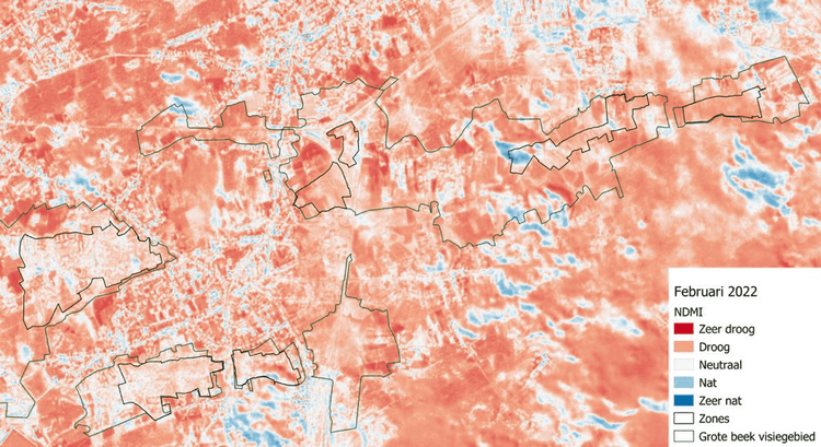
To monitor the area throughout the project, we analyse satellite images monthly. These images are taken with a so-called multispectral camera. Unlike an ordinary camera, this is a device that measures each wavelength (each colour) separately. So par example it measures whether there is a lot of red or little red in each pixel. And this for all colours and also different wavelengths within the infrared spectrum. By doing all kinds of calculations on this imagery, we can display things like plant activity, soil moisture, plant drought stress, eutrophication of open water.
By analysing the images throughout the year and over several years, we can see the effect of hydrological restoration in the peatland of the Vallei van de Grote Beek. Through this 'remote sensing', we can therefore quickly and comprehensively study how the area is evolving. Now we already have initial results over almost a year, but the real results will come after the valley is restored. Below is an example of how such a processed image looks like.
Normalized difference moisture index: an indicator of drought stress in plants. This aerial image highlights differences in water content in plant leaves. This is calculated using reflection of plants on specific wavelengths in the near infrared and short-wave infrared. Mind that only vegetated areas can be interpreted. In February, there were a lot of clouds. Their reflectance results in a big visual difference between this month and other months on this image. We see that the peatland is wet during winter, but dried out completely during summer. We hope to see improvements during the coming years due to the restoration in LIFE Multi Peat.
July 6, 2026
June 4, 2026
April 20, 2026
The content of this website has been machine translated for your convenience. All efforts have been made to provide accurate content; however, no automated translation is perfect. No guarantee is made or implied as to the accuracy or reliability of any automated translations made between English and any other language. Some content may not be accurately translated due to the limitations of the translation software. In the event of any discrepancy, misstatement, omission or error appearing in the various translations, the English version shall prevail.
Co-funded by the European Union. Views and opinions expressed are however those of the author(s) only and do not necessarily reflect those of the European Union or CINEA. Neither the European Union nor the granting authority can be held responsible for them.